We set off from the beach at Glenbrittle with a forecast that promised three days of fair weather with a 10-15 Knot N or NE wind. This meant that we should be on the sheltered side of the island with offshore winds, and hence have relatively flat sea conditions. However, with the 3000ft high Cuillin mountain range coming right to the shore along this section of coast, we might expect some gusts. The plan was to sail round to Loch na Cuilce, at the head of Loch Scavaig and camp there, where the river runs out over the rocks from Loch Coruisk. The Cuillins form a horseshoe around this loch with its mouth facing South to the sea. We planned to spend a day climbing the Dubh slabs up to the main ridge at Caisteal a Garbh-choire before finally returning by canoe again on the third day. As a yacht anchorage, our destination has the reputation of being very prone to squalls. Yachting literature abounds with tales of what a dark and forbidding place it can be. There is no road, no habitation, just you and the mountains. Eric Hiscock, that well known world cruiser of the 50’s, once had to unreeve all the running rigging from his gaff rigged yacht while at anchor there, to avoid her being laid flat by the gusts. On our previous visit, 25 years ago, my wife and I had arrived by tripper boat from Elgol. We camped, but the next day the weather had turned foul and it was clear that the boat would be unable to return, may be for several days. Climbing and walking prospects were poor, given the low cloud base and pouring rain, so we had little alternative but to walk back out , 14 miles, along the coast across the “bad step” carrying all our gear.
On this occasion, it was proving a hard job to get all our walking and scrambling gear into the canoe as well as full camping kit and food for 3 days.
I like to stop off and stretch my legs every couple of hours, especially on a sea passage. Our first stop was hence made just around the low lying headland of Rubh an Dunain. Here there is an improbable short section of canal with low rock walls, reputed to date from Viking times, which links a small low level lochan to the sea.


In the Viking Canal 
The entrance to the Viking Canal
It might have been fun to try and canoe through the canal at high tide, but unfortunately it is now too choked with small rocks.After lunch, we headed slightly offshore to the low island of Soay, famous for an ancient breed of sheep said to survive by eating seaweed.
We took another break on Soay. From here the wind became progressively more gusty as we got into the lee of the high mountains. We had to take down both the foresail and the mizzen as the precise direction from which the next gust might come became harder to predict and there was a significant risk of being caught aback. We continued to advance slowly using the paddles, just trying to hold our position during the strongest part of each gust.


Just beyond Ulfhart Point we took another break on a very stony beach, in the shelter, directly below Gars-bheinn, which forms the SW end of the horseshoe. It was now late afternoon and, although it was nice and sunny, looking out at the sea state and the one or two yachts we could see, it was clear that, around the point we would meet the full force of the N wind concentrated by funnelling down Loch Corusik between the mountains, almost directly towards us. I was sure that the wind would be too strong for us to paddle against it for two miles. I was not at all confident that we would be able to make sufficient progress to windward under sail either. My fallback plans were, either to reach across the wind to the beach at Camus Fhionnairigh where there might be some shelter below Sgurr na Stri which forms the SE end of the horseshoe, or , if the worst came to the worst, to run back round the point and camp where we were.
With the rig snugged down to reefed foresail and full mizzen, we headed out to see how bad it really was. The wind was about force 5, rather too much for a sailing canoe with 45 sq Ft of sail, but I did not think we would get far to windward with less. Fortunately it was at least blowing in a more constant direction here. The sea was covered with white horses but , as the fetch was so short, the waves were quite small. With both of us hanging right out we seemed to be able to keep the canoe upright enough, except in the strongest gusts. We battled on for a long time on Port tack but were taking in too much water from the breaking wave crests. Bailing was difficult as both of us were needed out on the sidedeck unless I spilt a lot of wind. Heaving–to would have resulted in a big loss of ground to leeward. Both shores were too rocky for landing.

I was on the point of abandoning our goal, but we had actually made a good distance to windward and, what’s more, the wind seemed to be changing direction slightly in our favour as we got further in towards the head of the sea loch. It seemed a pity to give up without a fight. As we got further in, the gusts became stronger. It was no longer possible to spill enough wind, as the boom of the foresail dragged in the water. My only hope was to pinch up to the wind and try and hang on to the tack long enough to bring us in to the shelter of a small hook of rock called Rubha Port Sgaile, or failing that a small rock island just off the cliff opposite the “bad step”. This course meant going very close to windward of one of the many isolated rocks in this part of the bay; there was also the risk that, by pointing so close to the wind, a gust would catch us on the lee side of the sail, and cause an instant capsize.
We made it into shelter before we foundered and where able to bail out and mentally regroup for a final couple of tacks to take us up behind Eilean Glas to arrive, near low water, on a mass of seaweed covered rocks below the outfall of the river. Here we were welcomed with tea by some sea kayakers who had been watching us with apprehension, wondering whether or not we would make it.

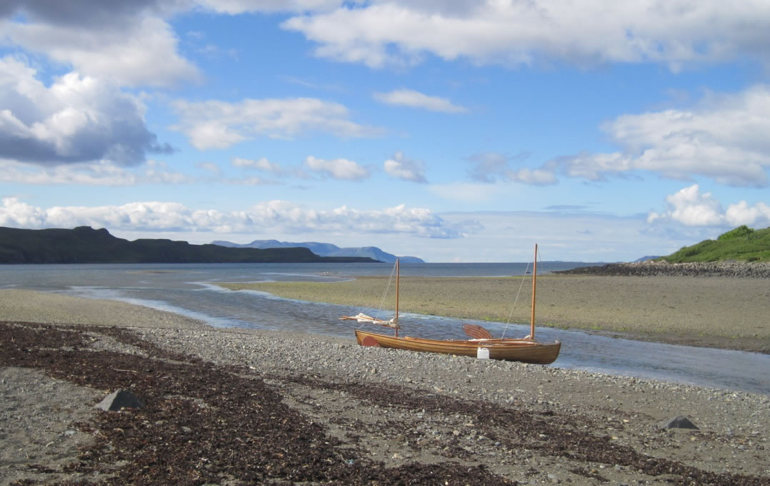
The canoe at the head of Loch Scarvig 
Camping at the head of Loch Scarvig 
Loch Corusik and the head of Loch Scavaig from the Cuillin Ridge at Caisteal a Garbh-choire